|
Location
Qoy Qırılg'an qala is in a remote desert location, just over 24km north northeast of To'rtku'l and 20km east southeast from Bostan.
It lies within the tuman of To'rtku'l.
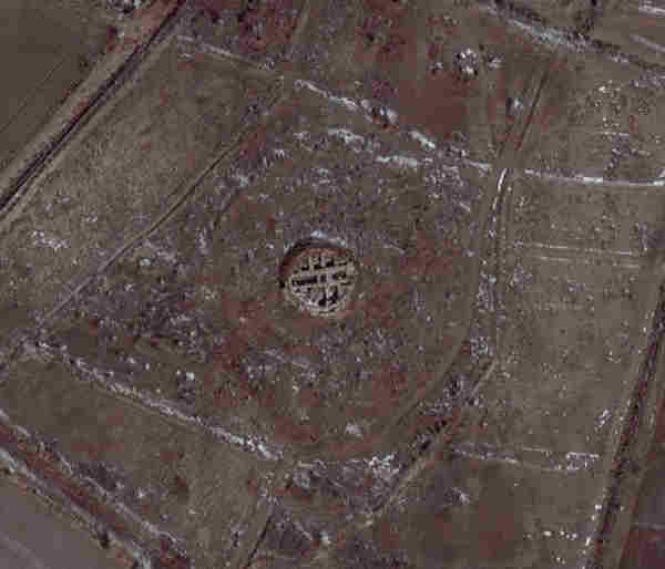
Aerial photograph of the remains of Qoy Qırılg'an qala. Image courtesy of Google Earth.
You can only reach the site by 4WD vehicle.
To get there from the centre of To'rtku'l drive west on the main road to Biruniy. After just over 2km, turn right and head north past the sports and
football stadium. Some 11.5km after the turn the road bends to the right and then bends back to the left. After 22.5km the road bends to the left
again. Just after 26km you reach a staggered cross road, with one side road to the right followed in a few metres by a side road to the left. Leave
the main road by taking the side road to the right.
This side road heads eastwards into the desert. 1.5km from the turn the road crosses a canal bridge and after 6km it reaches the ruins of Adamli qala,
an old Afrigid era feudal fort, just on the left side of the road. From this point Qoy Qırılg'an qala lies about 7.5km to the north. It
requires a 4WD jeep with a knowledgeable driver to reach it.
Excavations
The first archaeological viewing took place in 1938 when Sergey Tolstov, Yakh'ya Gulyamov, A. I. Terenozhkin and other members of the early Khorezm
Archaeological Expedition were encamped at nearby Teshik qala. In the distance they could see the silhouette of an unusual feudal fortress "sunk in
the sea of sand" and they examined it through binoculars. Eventually Tolstov set off to visit the site with his local guide, Sansyzbai Uryumov, some
camels and a photographer. The way was blocked by a number of huge barchans and they had to weave their way up and down the dunes and through the
hollows in between. They finally reached the summit of a barchan that provided a view across a landscape of takyrs covered with shards of
crimson pottery, with the ruins of a fantastically shaped fort beyond.
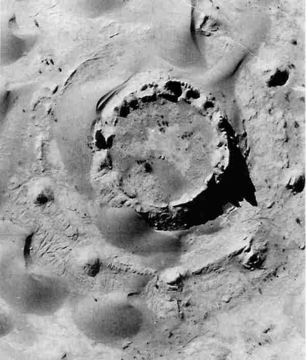
Aerial photograph of Qoy Qırılg'an qala lost in a field of barchans prior to its excavation.
It was not the fortress they had set out to reach. This particular ruin could not be seem from the top of Teshik qala. According to Tolstov, the
surprise find was deca-octagonal in shape, having eighteen corners, and its 5 to 6 metre high walls were covered with narrow closely spaced loopholes.
It was surrounded by a circular wall reinforced by the ruins of nine towers. The interior was filled with fragments of glazed and richly decorated
ceramics and Tolstov found bronze Scythian arrow heads and two terracotta statuettes.
The onset of world war ruled out any chance of more serious study and it was not until 1950 that the site was briefly visited again to assess its
suitability for serious excavation. It was accessed from the air by landing a small plane on a nearby takyr.
It was decided that the site was sufficiently unusual to warrant a detailed archaeological study and in 1951 the first team from the Khorezm
Archaeological Expedition arrived on 4WD trucks. Work proceeded between 1952 and 1957, during which every part of the site was exposed.
|
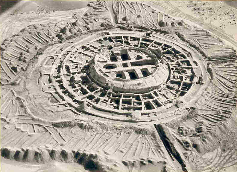
Aerial photograph of Qoy Qırılg'an qala at the height of the excavations.
The results of the work were summarized in a monograph written by Sergey Tolstov and Bella Vaynberg and published as Volume 5 of the "Works of the
Khorezm Archaeological-Ethnographical Expedition" in 1967. The work of conceptually reconstructing the architecture of the site was undertaken by
M. S. Lapirov-Skoblo.
Qoy Qırılg'an qala
Qoy Qırılg'an qala is a name that has been given to the site by local people over recent centuries. It is generally translated as
"Fort of the Dead Sheep". However the exact meaning of Qırılg'an is not dead but fragile or breakable.
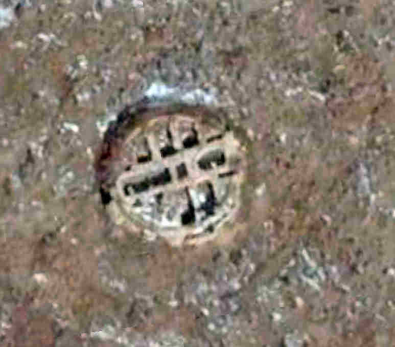
Aerial photograph of Qoy Qırılg'an qala. Image courtesy of Google Earth.
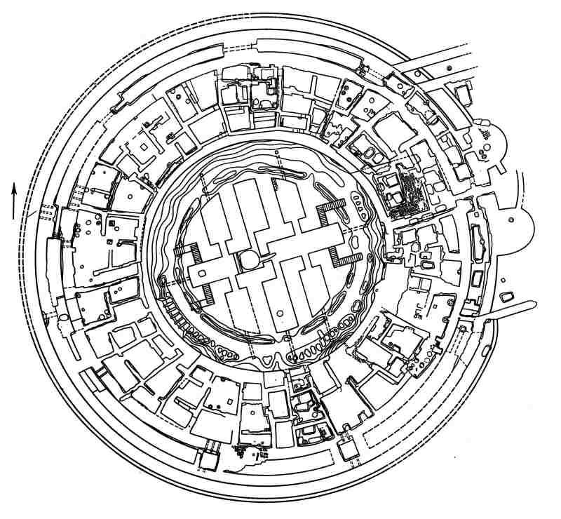
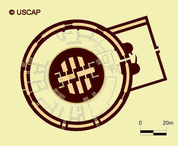
Plan of Qoy Qırılg'an qala.
Image courtesy of Associate Professor Alison Betts, University of Sydney Central Asian Programme.
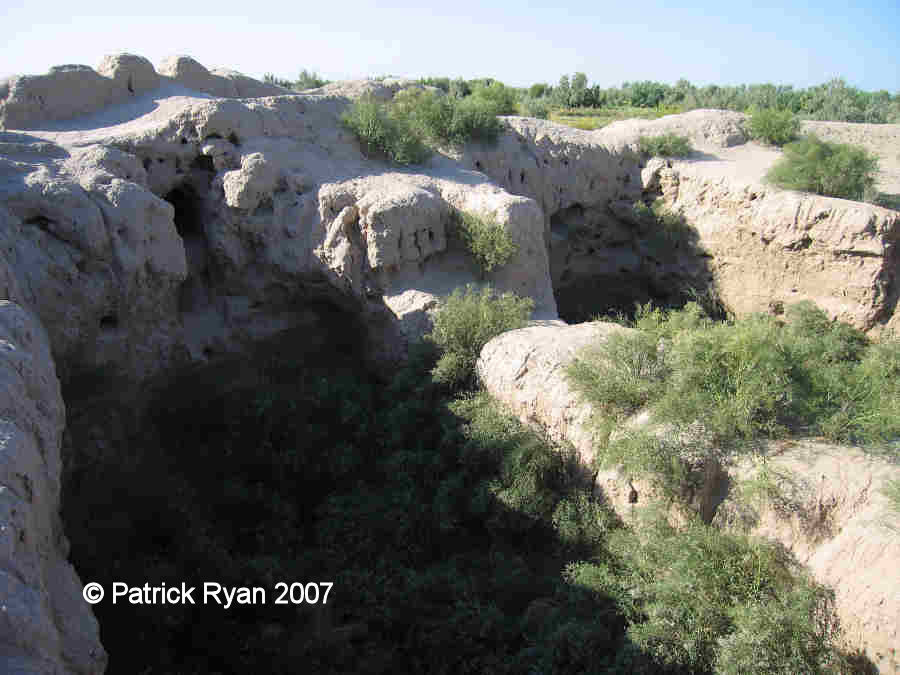
Today only the central part of the fort remains. It is in a badly eroded state. Soviet archaeologists tended to leave their completed excavations
exposed to the elements, and these mud-brick monuments are easily damaged by the winter rains. To make matters worse much of the mud brick from the
outer walls seems to have been taken and recycled by local people. Now the site faces an additional threat. The rising groundwater table is increasing
the levels of salinity around the site. Little has been left for re-examination by the scientists of the future.
Given the historical importance of the site the Ministry of Culture in No'kis even considered a plan in 2002 to rebuild Qoy Qırılg'an
qala and to use it to stimulate the local tourist industry. The chance of UNESCO or other funding seems unlikely.
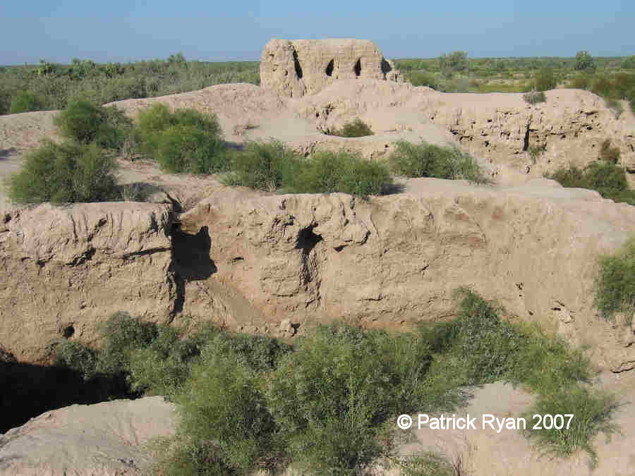
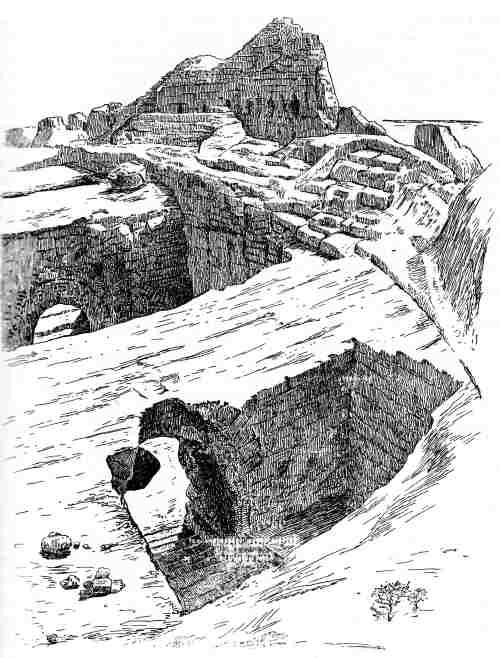
The remains of the central cylindrical building at Qoy Qırılg'an qala.
Images courtesy of Patrick Ryan, Glassboro, New Jersey.
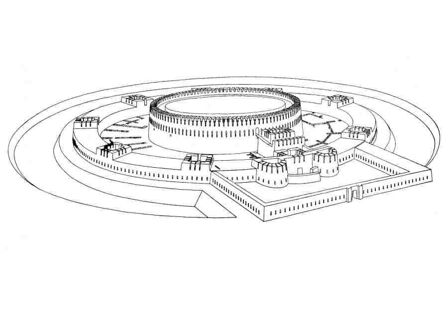
Excavation work has shown that Qoy Qırılg'an qala was a monumental two-storey cylindrical building, 42 metres in diameter, and standing
8 metres above the surrounding plain. There was a single row of arrow slits on the upper floor and a row of windows on the lower floor. The building
was defended by a circular outer double wall, 88 metres in diameter, reinforced with eight equally spaced bastions.
Detailed plan of Qoy Qırılg'an qala from 1957.
At first the building had been defended by a single outer wall and a surrounding ditch. At some time later the loopholes in this wall were sealed and
a second outer wall was added, creating a shooting gallery within the space between.
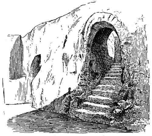
There was a single entrance located on the eastern side on the outer wall. Visitors first gained access to a rectangular courtyard and then passed
through a labyrinth gate defended by a pair of D-shaped towers. Once through the gate they passed up a covered ramp inside the gatehouse leading up
to the entrance of the central circular building.
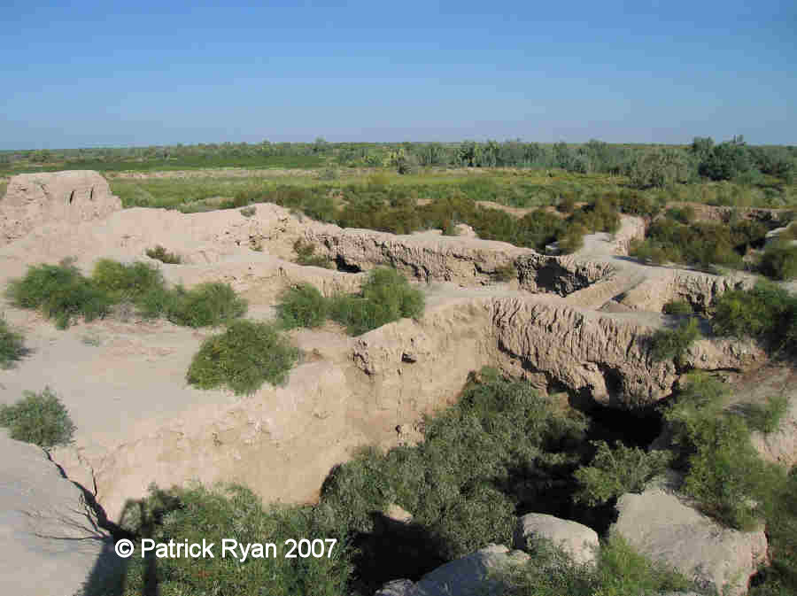
Looking down into the ground floor chambers at Qoy Qırılg'an qala.
Image courtesy of Patrick Ryan, Glassboro, New Jersey.
The ground floor of the main building contained eight chambers with arched ceilings, arranged into three interconnected groups. There were two
chambers aligned along a central axis, roughly oriented in an east-west direction, each accessed by pairs of descending stairways from opposite
sides of the building. There were then an additional six chambers oriented at right angles to the axial chambers in an approximately north-south
direction, three in the northern segment and three in the southern. Each central axial chamber was connected by narrow corridors to three of the
perpendicular chambers.
All of these chambers, apart from the central chamber on the northern side, were illuminated by downward sloping window shafts penetrating the six
metre thick wall.
To complicate matters further, the central chamber on the western side had been divided at some later stage into two parts by a wall. A deep pit had
been dug in the floor of the smallest segment. Furthermore while the eastern stairs led up to the second storey archers' gallery which encircled the
building, the western stairs leading off from the western chamber had also been blocked by a brick wall.
The upper floor had to be accessed by ladders from the second storey archers' gallery.
|
|
|
Sketches of parts of the excavated site drawn by Igor Savitsky in the 1950's.
Even today, the true purpose of the site still remains something of a mystery. Excavations showed that the building had been destroyed by fire and
had later been ransacked. It seems to have originally been built in the 4th century BC shortly after Khorezm gained its independence from Persia.
This period, originally named after the Kangyuy culture of the middle Syr Darya and now called the Early Antique Period, saw a huge blossoming of
Khorezmian culture. Yet surprisingly the building was used for only one or at most two centuries before being abandoned in the early 2nd century BC.
It was then briefly occupied by squatters.
It is possible that the lower floor might have originally functioned as some type of astronomical observatory, possibly monitoring the times for the
rising and setting of certain stars and perhaps the cycles of the sun and the moon, given their highly venerated position in Zoroastrianism. We do
know that the Khorezmians were familiar with eclipses, had an accurate calendar and knew the exact time of the seasons – vital for the management of
their agricultural economy.
|
Architectural drawing of the Qoy Qırılg'an qala building.
In the middle of the 2nd century BC the site was reoccupied and experienced a revival up until the 4th century AD. The space between the central
circular building and the surrounding wall became increasingly filled with an irregular radial arrangement of storerooms and domestic buildings and
a defensive proteichisma was built just two metres outside of the external wall. The site seems to have become the centre of a local cult
that was associated with the consumption of wine. Numerous finds revealed that wine making and drinking had now become a popular pastime. Apart
from numerous storage jars and drinking vessels, archaeologists found paintings of a bearded man holding a bunch of grapes and a wine jug and a woman
pouring an amphora into a goblet. The surrounding agricultural region seems to have been a rich wine growing area and from various finds of grape
pips we even known the varieties of vines that were being grown. An aerial survey in the early 1950s identified the remains of many grid-shaped
irrigation systems in the vicinity of Qoy Qırılg'an qala, slowly being invaded by desert barchans.
One final mystery concerns the segmentation of the western central chamber. It has been suggested that the observatory may have been subsequently
used as a royal mausoleum or burial site, since part of the chamber had been isolated by thick walls. A very deep pit, possibly designed to foil
grave robbers, protected the approach to the dividing wall from the eastern side. It was so effective that it nearly consumed the archaeological
excavators who first discovered it. There are some similarities between the design of the chambers at Qoy Qırılg'an qala and those
found at Tagisken and Chirik Rabat. However the bricked-up chamber contained no remains of any burial.
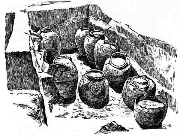
Six seasons of work at Qoy Qırılg'an qala revealed a huge amount about the material culture of Khorezm during the Early Antique Period.
Finds included a rich collection of ceramics, statuettes, fragments of polychrome painting, iron tools and arrow heads, ossuaries (see below), and
inscriptions written in the Khorezmian dialect of the Aramaic language.
Ossuary Burial Urns
It was during the time of Qoy Qırılg'an qala that a new burial ritual was introduced into Khorezm that may have originated further west,
in the Middle East, since the most ancient ossuary burials are found in Israel. It is possible that the practise emerged as a new means of expressing
the ancient cult of ancestor worship. The ritual is quite unusual and is not even found in Persia.
Zoroastrians believed that the human body polluted the sacred elements of earth, fire and water. Instead of burial or cremation, the corpse was exposed
under the purifying sun, so that the corrupting flesh could be stripped away by wild birds and animals, leaving behind the cleaned and bleached bones.
These then had to be buried to prevent them polluting the soil and vegetation.
This was achieved in Khorezm by placing the bones in hollow ceramic ossuarys, generally moulded in the shape of a person. Indeed, archaeologists
suspect that the ossuarys were originally made with a copy of the head of the deceased person placed on the body of a god – one ossuary has even been
found with the body of a camel, representing the Khorezmian god Vertragna. The ossuary was subsequently kept in the home or farmstead, or placed in
a mausoleum or niche. In time ruined fortifications, temples or other important sites increasingly became used as Zoroastrian burial grounds.
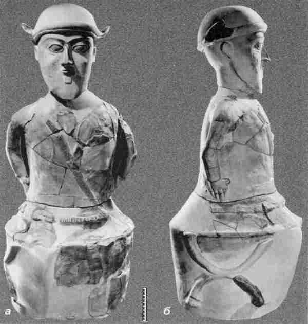
Two ossuaries recovered from Qoy Qırılg'an qala, the first showing a bearded man with hat and jacket
and the second another bearded man, sitting cross-legged wearing a hat and waist belt.
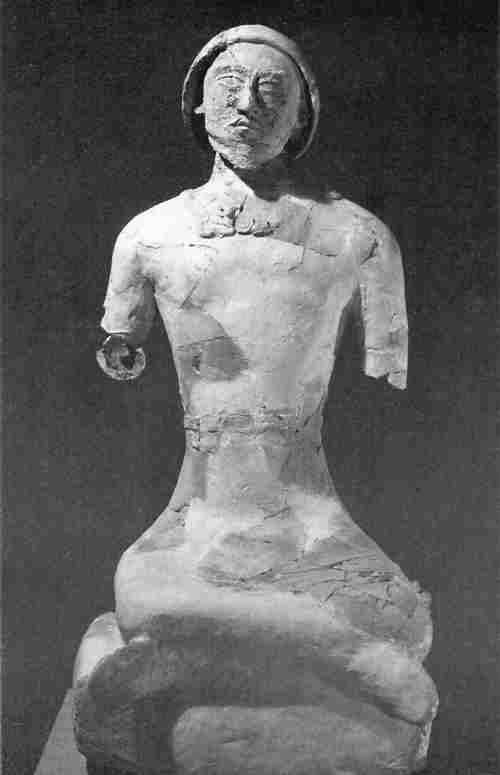
The site of Qoy Qırılg'an qala revealed several different types of ossuary, from a simple box-shaped container with a pyramid shaped top,
to a woman seated on a rectangular box, and finally one fashioned into the shape of a bearded man sitting in a cross-legged position.
Google Earth Coordinates
The following reference point (in degrees and digital minutes) will enable you to locate Qoy Qırılg'an qala on Google Earth:
| | Google Earth Coordinates |
|---|
| Place | Latitude North | Longitude East |
|---|
| Qoy Qırılg'an qala | 41º 45.317 | 61º 7.020 |
| Adamli qala | 41º 44.450 | 61º 7.338 |
| | | |
Note that these are not GPS measurements taken on the ground.
Visit our sister site www.qaraqalpaq.com, which uses the correct transliteration, Qaraqalpaq, rather than the
Russian transliteration, Karakalpak.
Return to top of page
Home Page
|
|